User map [Deleted]

Map Height

I did a quick search and did not find anything on this: It looks like the width is set to 1005, but the Height is fixed at 540? Is there any way to adjust the height?

Thanks!
 
Oddly, it is actually. Also not sure what 1005 is.

I did answer from the train last night on my way home from (yet another) Christmas parties. I might have had a little to much to drink. Hick.


Will double check later today when the jackhammer in my head shuts down.:sleep:
 
Hello @CrispinP

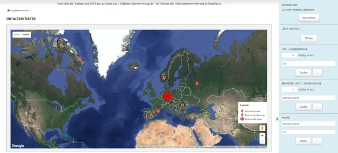
I know its a time, you are busy - but what I realy miss is a search in the Membermap to find ( and display them on the map ) other members near to my location.
So that I only input a radius in km, press on search and the map displays me only all members within this range. :)

Do you think, you can do this - I see a other map (Woltlab Forum), that has this feature and I found it realy cool. :D

Other cool stuff:
- view only all staffs
- view only all members in my group or group xyz (nice for social group addons)
...

I think that will be a grand feature for your cool map addon. (y)
 
I know its a time, you are busy - but what I realy miss is a search in the Membermap to find ( and display them on the map ) other members near to my location.
So that I only input a radius in km, press on search and the map displays me only all members within this range. :)

Do you think, you can do this - I see a other map (Woltlab Forum), that has this feature and I found it realy cool. :D

Do you have a link to that? Sounds really good, I was thinking about a similar feature too.

What would be quite cool is if Crispin's map integrated with XenAtendo 2.

So you could select 'Invite' on an event thread, specify a km distance radius from the event location, and all members within that radius on the map would receive an invite alert. Maybe a preview with a circle over map too, so you can confirm it's covering the geographic location you think it's covering before the invites go out. And perhaps a number amount and list of all users in the catchment area, before it gets confirmed.

Would be great for meetups on our forum. And save trying to remember specific members usernames to send individual invites, which is very cumbersome and a bit lame as it's hard to remember individual usernames, especially in built up areas where a lot of members may need event invites.
 
Hi,

Can you CP me the PayPal email address you used? Somehow I don't have you on the list.
Done, thanks.

Next question. What do you think about moving your extra fields from xf_user_profile into it's own table? InnoDB doesn't support SPATIAL indexes so it would be handy to use your POINT location data for other purposes if it was in a MyISAM with an index instead. It's too slow otherwise for spatial queries.
 
Next question. What do you think about moving your extra fields from xf_user_profile into it's own table? InnoDB doesn't support SPATIAL indexes so it would be handy to use your POINT location data for other purposes if it was in a MyISAM with an index instead. It's too slow otherwise for spatial queries.

I've been edging towards that. The other plugin I am writing does something similar and uses that. I'll bear it in mind when I next change it.


Out of curiosity - what spatial queries are you running?


C
p.s.
I'm on holiday for the next week or so so replies might be slow.
 
Out of curiosity - what spatial queries are you running?
This basic spatial query for a distance from a specific point is a good example on only about 4k rows that have location data

Code:
SELECT
  user_id,
  X(cum_map_location) AS "latitude",
  Y(cum_map_location) AS "longitude",
  (
    GLength(
      LineStringFromWKB(
        LineString(
          cum_map_location,
          GeomFromText('POINT(39.900757 -76.606021)')
        )
      )
    )
  )
  AS distance
FROM xf_user_profile
WHERE cum_map_location IS NOT NULL
  ORDER BY distance ASC
  LIMIT 0,30;
The main sorting stage of the query is about 5-10 times slower on the InnoDB with no index.

I'm also doing an accurate distance query taking into account longitude differential which shows some difference as well but is mostly restricted by the function math. Just playing around today and figuring out various methods for semi-accurately finding other users close without too much SQL work.

Code:
drop function if exists lineDistanceC;
delimiter //
CREATE FUNCTION lineDistanceC (la1 DOUBLE, lo1 DOUBLE, la2 DOUBLE, lo2 DOUBLE) RETURNS DOUBLE
BEGIN
    SET @r = 6371;
    SET @lat1 = RADIANS(la1);
    SET @lon1 = RADIANS(lo1);
    SET @lat2 = RADIANS(la2);
    SET @lon2 = RADIANS(lo2);
    SET @x = (@lon2-@lon1) * COS((@lat1+@lat2)/2);
    SET @y = (@lat2 - @lat1);
    RETURN (SQRT((@x*@x) + (@y*@y)) * @r);
END
//
delimiter ;

SELECT
  user_id,
  location,
  lineDistanceC(X(cum_map_location),Y(cum_map_location),39.900757,-76.606021) AS distance
FROM xf_user_profile
WHERE cum_map_location IS NOT NULL
  HAVING distance <=75
  ORDER BY distance ASC
 
@CrispinP I do not want these fields in User Sign up but I still like it as an option in user profile.

Latitude, Longitude and map location
Screen Shot 02-13-17 at 08.11 AM (2).webp
I didn't see a way to just disable it in User Registration?
 
No idea what the Latitude and Longitude fields are. Not my add-on.

As for the Map Location - it should not (I don't think) be shown by default. Did you enable it by mistake?
Nonetheless, you can turn it off here:
upload_2017-2-13_13-28-32.webp

HTH
C
 
It might be from one of the Location Autocomplete add ons.

I remember when I disabled it, those two fields appeared on my registration form too.
 
Is this responsive? Looking at the demo page it doesn't seem to be, or is responsiveness available as a setting?
 
In so much as the map resizes accordingly - yes. There's nothing much else to do from a UI PoV.

What makes you say it's not?
 
Top Bottom